Today, Stay Weather Aware Between Noon and 10 pm
Current Weather Conditions:
None at this time
Expired Weather Conditions:
Tornado Watch for Fayette, Lamar, and Walker counties until 8 pm.
There is Significant Weather Advisory for Fayette, SE Lamar, and N Walker counties until 6 pm.
There is a Severe Thunderstorm Warning for Fayette, Lamar and Walker county until 630 pm.
There is a Flood Advisory for Lamar county until 715 pm.
Severe Thunderstorm Warning Fayette and Lamar counties until 515 pm.
Significant Weather Advisory for Northern Lamar county until 5 pm
Tornado Watch for Lamar County until 4 pm.
Flash Flooding will be possible for portions of Central Alabama. The Flash Flood Watch includes the following counties: Bibb, Greene, Hale, Perry, Sumter, and Tuscaloosa. (and others but not in our coverage area)
There is a Flood Advisory until 11:15 am for the following counties: Bibb, Greene, Hale, and Tuscaloosa. Turn around; don’t drown when encountering flooded roads. Most flood deaths occur in vehicles.
There is a Flood Advisory until 10:30 am for the following counties: Greene, Northwestern Hale, & Sumter.
Overall Outlook for Today:
Today, Stay Weather Aware Between Noon and 10 pm
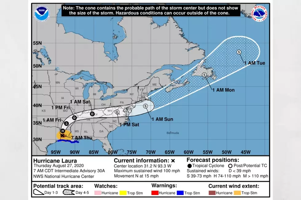
It seems like it has been non-stop weather action since last week. Well, it has, and today is no different. Currently, as the Gulf of Mexico is quiet, Tropical Depression Laura is over northeastern Arkansas and moving towards the Ohio Valley. However, today, please, stay weather aware between Noon and 10 pm. Be sure you take the time out to have an easy way to get your weather information, watches, and warnings. We offer a free app, which you can sign up for breaking news, exclusives, and weather alerts.

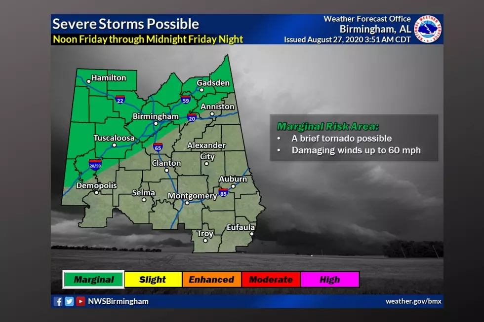
For Today, Friday, August 28, 20202, The National Weather Service has placed most of our listening areas in a split between “Marginal Risk Area” and "Slight Risk Area". The "marginal risk area" means it includes the threat levels of the "slight risk area" but is less likely but cannot be ruled out which could mean that a “tornado is possible and damaging winds up to 60 mph.” My advice, regardless of the area you are in, stay weather aware of all the conditions. The current projected timeline is between Noon and 10 pm.
There is a Hazardous Weather Outlook from the National Weather Service for today, which the “remnants of Laura may bring a threat for damaging winds and a brief tornado between Noon and 10 pm. Areas with the greatest potential will be along and northwest of an Aliceville to Warrior line, with a marginal risk along and north of a Livingston to Anniston line.” This affects the following counties: “Marion-Lamar-Fayette-Winston-Walker-Blount-Etowah-Calhoun-Cherokee-Cleburne-Pickens-Tuscaloosa-Jefferson-Shelby-St. Clair-Talladega-Clay-Randolph-Sumter-Greene-Hale-Perry-Bibb-Chilton-Coosa-Tallapoosa-Chambers-Marengo-Dallas-Autauga-Lowndes-Elmore-Montgomery-Macon-Bullock-Lee-Russell-Pike-Barbour.”
(Source) For more from the National Weather Service, click here.
More From Catfish 100.1