Expect Active Weather Today, Friday in West, Central Alabama
The National Weather Service in Birmingham has issued a Severe Thunderstorm Watch until 10 pm for the following Townsquare Media Coverage Areas:
Bibb
Fayette
Greene
Hale
Lamar
Pickens
Sumter
Tuscaloosa
Walker
Special Weather Statement from the NWS
A strong thunderstorm will impact portions of southeastern
Tuscaloosa and north central Bibb Counties through 215 PM CDT...
At 142 PM CDT, Doppler radar was tracking a strong thunderstorm over
Mercedes Benz Of Alabama, or 14 miles east of Holt, moving east at 5
mph.
HAZARD...Wind gusts up to 50 mph and nickel size hail.
SOURCE...Radar indicated.
IMPACT...Gusty winds could knock down tree limbs and blow around
unsecured objects. Minor damage to outdoor objects is
possible.
Locations impacted include...
Vance, Woodstock, West Blocton, Tannehill Ironworks State Park,
Mercedes Benz Of Alabama, North Bibb, Green Pond, Caffee Junction and
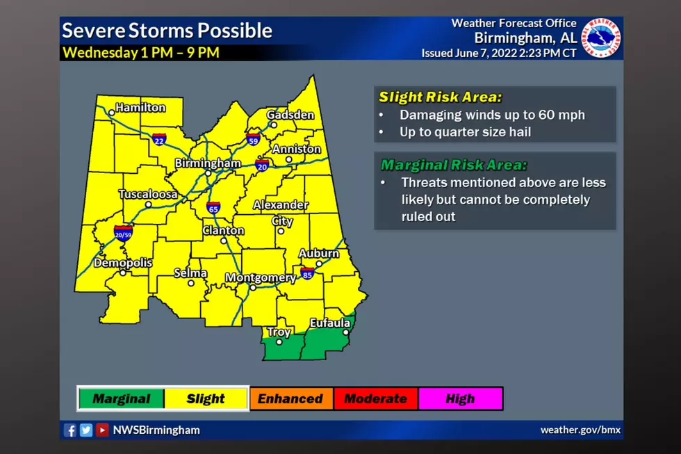
Hebron.Today, Wednesday, June 8, The Storm Prediction Center (SPC) has placed the Townsquare Media coverage areas under a "slight risk" which is a level 2 out of 5 for severe thunderstorms. The main threats to this system are damaging winds and hail.
Where: All of Central Alabama
When: Afternoon and Evening
Threats: Damaging winds and large hail
Immediate Weather Information
The National Weather Service in Birmingham has issued an Areal Flood Watch for the following counties: Bibb, Blount, Calhoun, Cherokee, Chilton, Clay, Cleburne, Coosa, Etowah, Fayette, Jefferson, Marion, Randolph, Shelby, St. Clair, Talladega, Tuscaloosa, Walker, and Winston until Jun 09, 1:00 AM CDT.
James Spann, ABC 33/40, and Townsquare Media Tuscaloosa Chief Meteorologist said that “some communities have picked up over three inches of rain over the past 6 hours with this batch of storms. The rain tapers off and ends by mid-morning, but another batch of storms is likely late this afternoon and tonight.”
Flooding Concerns
“We will also have to watch for more flooding issues with the afternoon and evening storms since the ground is now totally saturated in many places,” said Spann.

More Storms on Friday
The National Weather Service in Birmingham noted that “a warm front will lift northward on Friday and bring a potential for more severe storms, mainly across the western counties.”
Friday:
Where: Western two-thirds of Central Alabama
When: Afternoon and Evening
Threats: Damaging winds and large hail
We will continue to monitor this weather situation closely and bring you any updates.
(Source) Click here to follow the Facebook Page for James Spann. For more from the National Weather Service Birmingham, click here.
Top Stories from the Tuscaloosa Thread (5/31 - 6/6)
New Tuscaloosa Restaurants & Retail in 2021
Tuscaloosa Restaurants and Stores That Closed for Good in 2021
More From Catfish 100.1