Tropical Storm Sally is Intensifying
Tropical Storm Sally is Intensifying

[Update Sunday, September 13, 2020, at 4:45 pm]
- Sally could be upgraded to a hurricane later tonight or tomorrow morning.
- The slow-moving system continues to gain strength while in the Gulf of Mexico.
- The tropical storm (pending hurricane status) is still on track towards southeast Louisiana for landfall Monday night.
- This slow movement is very concerning as it could enhance the rain levels, increased flooding potential, and storm surges.
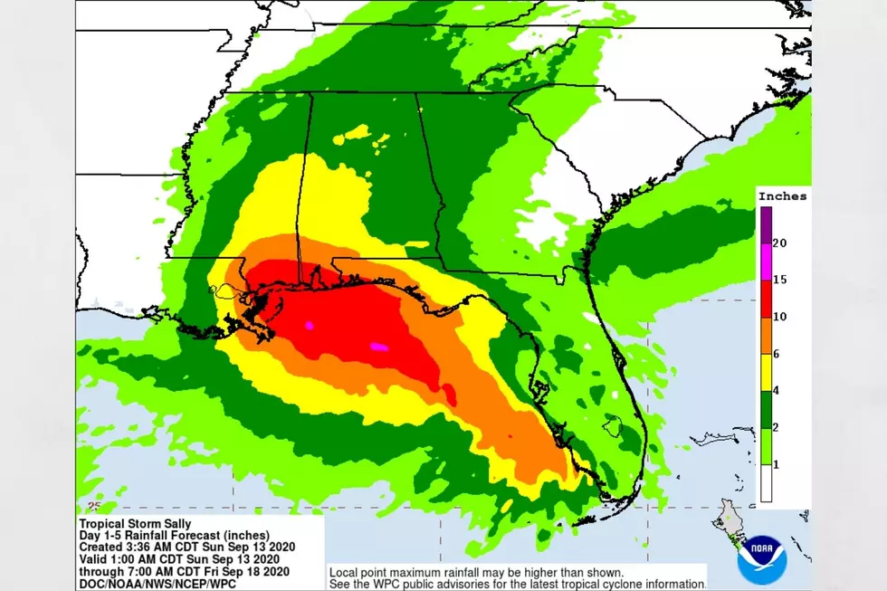
Currently, the impacts to our listening areas are possible Wednesday and Thursday that include widespread rain.
- Southwest Alabama could see rain amount totals near 4 to 6 inches
- North and Central Alabama could see rain amount totals near 3 to 4 inches.
- Potential for severe weather that includes the possibility of tornadoes
As Sally gets closer, there will be more clarity in what could take place in our listening areas.
I do stress that any change in variables with Sally could change the predictions for our area. It is always best to stay informed. According to the Weather Channel, “Louisiana's governor declared a state of emergency and called the storm "a very significant threat.” Also, “the mayor of New Orleans tells residents living outside the levee system to evacuate.”
The track, timing, warning, and watches are still current and information is listed below.
(Source) For more from the Weather Channel, click here.
[Update Sunday, September 13, 2020, at 2:40 pm]
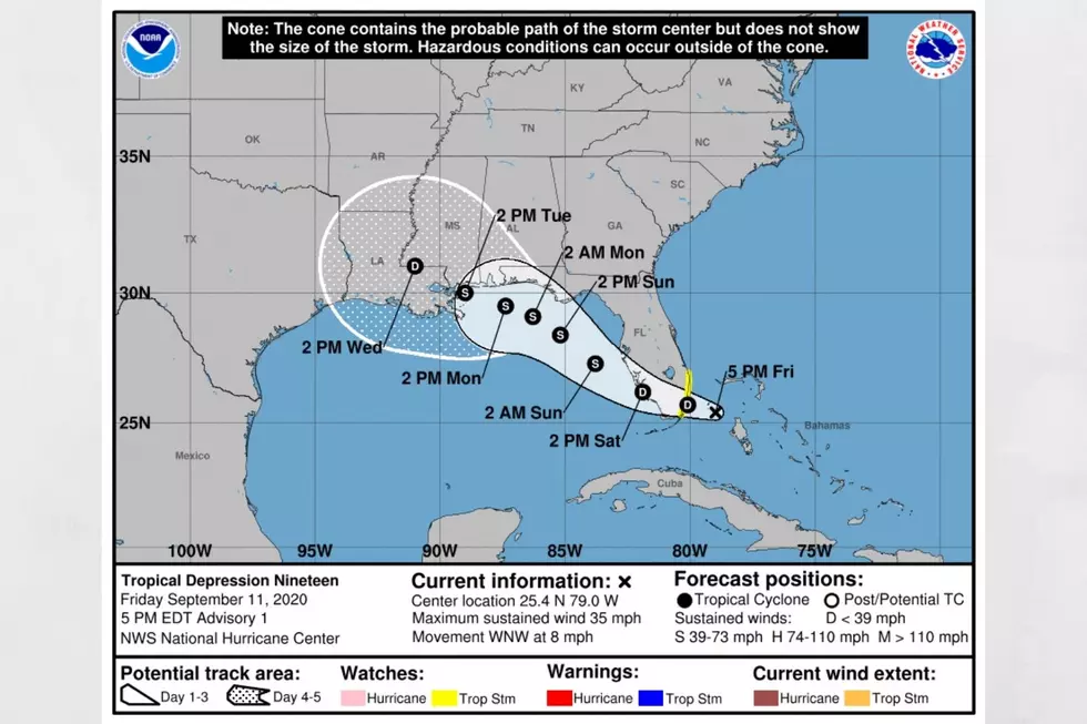
We are still tracking Tropical Storm Sally, which continues in a west-northwestward path over the eastern Gulf of Mexico. Also, Sally is still appearing to be a slow-moving system and continuing to strengthen.
There are still concerns for life-threatening storm surge, hurricane-force winds, and heavy rainfall for those in the warning areas of the northern Gulf Coast on Monday. Also, tropical storm conditions are possible within those watch areas beginning on Monday.
Current warnings, watches and Central Alabama impacts remain the same. That information was posted earlier and is below.
[Update Sunday, September 13, 2020, at 8:30 am]
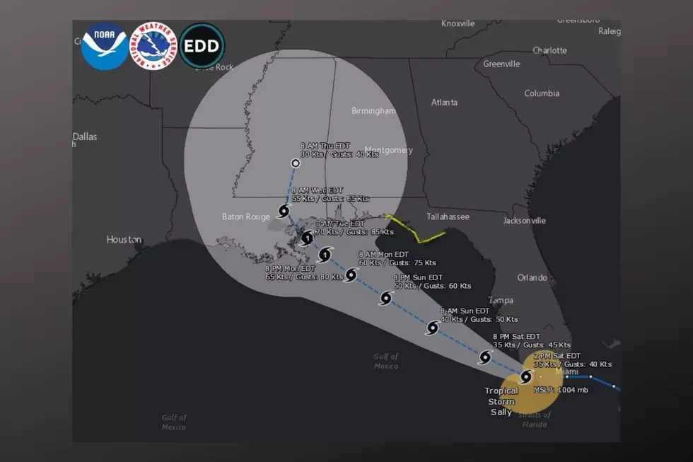
Tropical Storm Sally is intensifying with a prediction to make landfall on Monday night around the mouth of the Mississippi River with the center passing over New Orleans. However, this could change with any variance in Sally’s current progression.
Central Alabama Impacts:
After Sally makes it landfall, the system should weaken and track through southern Mississippi Tuesday evening. The timing for our area is for Wednesday night and early Thursday, more than likely as a tropical depression. Again, I stress that any change in Sally’s track could change our local impacts.
Winds for our area could be between 30-35 mph.
We could see the rainfall amount for our area range from 3 to 6 inches.
There is a concern for flooding as well.
There is also the threat of Tornadoes as well for our area Wednesday night into Thursday.
Movement:
Currently, Sally is moving at 13 mph in a west-northwest direction. It is predicted that an expected to shift will take place heading into a west-northwestward or northwestward direction. Also, possibly on Tuesday, there could be a turn toward the north-northwest track and decrease in speed.
Timing:
Sally still has the potential to reach hurricane status.
The system could always demonstrate signs of strengthening as well over the next few days.
Today, the tropical storm is moving over the southeastern and eastern Gulf of Mexico.
Tonight, Sally should move over the north-central Gulf of Mexico.
Late Monday, the prediction is for the system to approach the hurricane warning areas of the north-central Gulf Coast.
Current Warnings and Watches:
Hurricane Warning is in effect for Grand Isle, Louisiana, to Ocean Springs, Mississippi. Also, for Lake Pontchartrain and Lake Maurepas, including metropolitan New Orleans
Storm Surge Warning is in effect for Port Fourchon, Louisiana, to the Mississippi/Alabama border. Also, for Lake Pontchartrain, Lake Maurepas, and Lake Borgne
Storm Surge Watch is in effect for the Mississippi/Alabama border to the Alabama/Florida border
Hurricane Watch is in effect for East of Ocean Springs to the Alabama/Florida border
Tropical Storm Warning is in effect for East of Ocean Springs to Indian Pass
Tropical Storm Watch is in effect for Indian Pass to Ochlockonee River, Florida
What can I say? It has been a very active hurricane season for 2020. According to the Weather Channel, “Sally is the earliest "S" storm to form during a season on record, beating 2005's Stan by 3 weeks.” Also, hurricane season runs until November 30, 2020. We will continue to monitor Sally and what it means for Central Alabama.
Mary K – weather forecaster.
(Source) For more from the Weather Channel, click here.
Hurricane Terms You Need to Know
More From Catfish 100.1