NWS Confirms EF-0 Tornado for Southwest Jefferson County
NWS Confirms EF-0 Tornado for Southwest Jefferson County

There was unsettling weather Sunday evening into the overnight hours Monday for Alabama. According to the National Weather Service Birmingham, the brief tornado that took place near Bessemer was “the 100th documented tornado in Jefferson County since 1950.”
We were on standby for the weather situation yesterday for our coverage area. However, the troubling weather situation was in southwest Jefferson County, labeled the “Dusty Lane Tornado.” It started at 1:02 am and end at 1:08 am
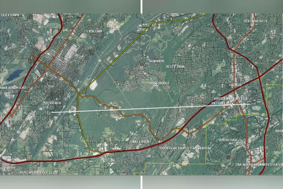
The Jefferson County EMA completed the damage assessments and helped determine that the Dusty Lane Tornado was an EF0 with estimated peak winds at 80 mph. It has a path length of 4.8045 miles with a width of 350.0 yards.
Here is the survey summary from the National Weather Service:
THE TORNADO FIRST TOUCHED DOWN ON DUSTY LANE, CAUSING DAMAGE MAINLY TO WEAKENED OR SHALLOW ROOTED TREES. THE TORNADO CROSSED MORGAN ROAD AND CONTINUED EAST ACROSS AN INACCESSIBLE FORESTED AREA, CROSSING SHADES CREEK AND THEN PASSING JUST BEHIND THE OAKS ON PARKWOOD BLVD. SCORES OF TREES WERE EITHER UPROOTED OR SNAPPED IN THE AREA, AND MINOR STRUCTURAL DAMAGE WAS NOTED AT THE OAKS. THE TORNADO CONTINUED EASTWARD AND REACHED ITS PEAK INTENSITY AS IT CROSSED PARKWOOD ROAD JUST WEST OF ALABAMA HIGHWAY 150, WITH A DOZEN OR SO VERY LARGE HARDWOODS UPROOTED, CAUSING DAMAGE TO HOMES AND VEHICLES. THE TORNADO WAS ALSO ESTIMATED TO BE AT ITS MAXIMUM WIDTH OF ABOUT 350 YARDS IN THIS AREA AS IT CROSSED AL 150. THE TORNADO NARROWED AND WEAKENED AS IT CROSSED ANOTHER AREA OF FORESTED LAND, BEFORE SNAPPING AN OLDER TREE ALONG ROSS BRIDGE PARKWAY JUST WEST OF DEER VALLEY ELEMENTARY SCHOOL, THEN SKIRTED THE NORTH END OF THE CAMPUS BEFORE ASCENDING SHADES CREST MOUNTAIN, THEN RAPIDLY DISSIPATING AS IT CROSSED SHADES CREST ROAD.
All tornado threats should be taken seriously. The Enhanced Fujita Scale Classifies Tornadoes into the following categories:
EF0...WEAK......65 TO 85 MPH
EF1...WEAK......86 TO 110 MPH
EF2...STRONG....111 TO 135 MPH
EF3...STRONG....136 TO 165 MPH
EF4...VIOLENT...166 TO 200 MPH
EF5...VIOLENT...>200 MPH
(Source) For more from the National Weather Service Birmingham, click here to follow their Facebook page. For more from the NWS Damage Survey from the 12/14/20 Tornado Event, click here.
Clouds: Artwork In The Sky
More From Catfish 100.1