What Alabamians Need To Know About Zeta
UPDATE: 5:08 pm on October 27, 2020, from the National Weather Service
The National Weather Service commented on their Facebook page some further direction about a timeline for tomorrow. "Central Alabama will remain unsettled tonight, but the main action associated with "Zeta" will come to our area starting Wednesday (especially in the afternoon). #alwx"
UPDATE: 4:45 pm on October 27, 2020, from the National Weather Service
There is a Flash Flood Watch from Wednesday 4 pm until Thursday 10 am for counties in our listening areas. This includes Bibb, Greene, Hale, Jefferson, Perry, Shelby, and Tuscaloosa.
UPDATE: 4:05 pm on October 27, 2020, from the National Weather Service
Tuscaloosa County has been added to the Tropical Storm Watch.
UPDATE: 3:15 pm on October 27, 2020, from the National Weather Service
**TROPICAL STORM WATCH ISSUED FOR CENTRAL AND EASTERN ALABAMA**
NEW INFORMATION
---------------
* CURRENT WATCHES AND WARNINGS:
- A TROPICAL STORM WATCH IS IN EFFECT FOR AUTAUGA, BIBB, CALHOUN,
CHAMBERS, CHEROKEE, CHILTON, CLAY, CLEBURNE, COOSA, DALLAS,
ELMORE, ETOWAH, HALE, JEFFERSON, LOWNDES, MARENGO, MONTGOMERY,
PERRY, RANDOLPH, SHELBY, ST. CLAIR, TALLADEGA, AND TALLAPOOSA
* STORM INFORMATION:
- ABOUT 810 MILES SOUTH-SOUTHWEST OF BIRMINGHAM AL OR ABOUT 740
MILES SOUTH-SOUTHWEST OF MONTGOMERY AL
- 22.1N 90.1W
- STORM INTENSITY 65 MPH
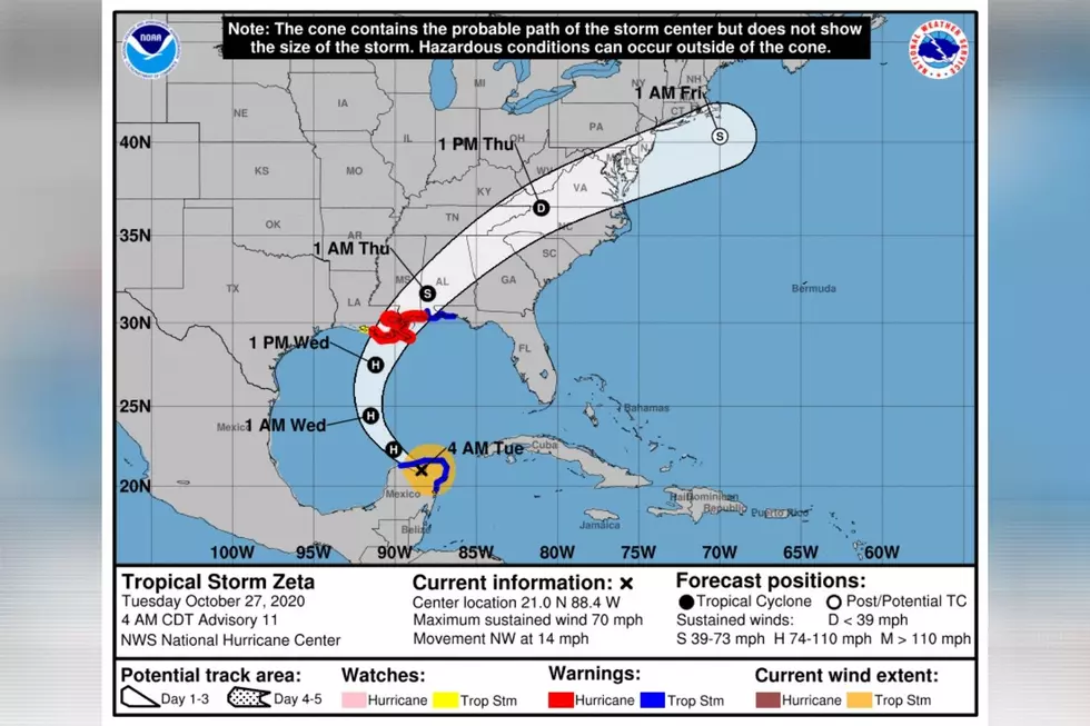
- MOVEMENT NORTHWEST OR 305 DEGREES AT 14 MPHThe Atlantic’s 11th hurricane of the season has been downgraded to a tropical storm. It also appears to be aiming for the northern Gulf Coast. The overall main concern for those in Zeta's track is heavy rainfall, strong winds, and storm surge.
This morning Zeta is a tropical storm located over the tip of the Yucatan Peninsula. The storm is moving northwest at 14 miles per hour. The system's maximum sustained wind speeds are at 70 miles per hour.
Tuesday night, Zeta should turn towards the north. Then will track northward then northeastward. It should approach the northern Gulf Coast at or near hurricane strength on Wednesday. The expected landfall is over Southeast Louisiana. However, any shift in the track could change this information. Thoughts are that Zeta could be a strong tropical storm or a low-end hurricane at the time of landfall.
Information about Zeta for our coverage areas
Winds: “Gusts 40-60 mph Wednesday night, south of I-20.”
Tornado: “Marginal risk of tornadoes Wednesday night, south,”
Rainfall: “2 to 4 inches through Thursday, localized flooding possible.”
"Tropical Storm Watch from Wednesday 7pm until Thursday 10am for Autauga, Chilton, Coosa, Dallas, Elmore, Lowndes, Marengo, Montgomery, and Perry."

MORE DETAILS from the National Weather Service Birmingham, “Impacts from Zeta will mainly occur Wednesday night, primarily south of I-20. Sustained winds of 20 to 40 mph are likely, with wind gusts up to 60 mph possible. Rainfall may be locally heavy at times, with two to four inches of rain expected through Thursday, including some locally higher amounts. This may cause localized flooding. There is also a potential for isolated tornadoes Wednesday night across the southern one-third of Central Alabama, mainly along and south of a Linden, to Selma, to Lafayette line.”

A tropical storm watch is in place for parts of Central Alabama for winds up to 45 miles per hour. There is a tropical storm warning in effect for parts of South and Southeast Alabama. The Alabama Gulf Coast and the Florida Panhandle are under a tropical storm warning. At this time, the tornado threat should be contained to the southern half of the state.

The governor of Louisiana has declared a state of emergency ahead of Zeta’s arrival. CNN said that if Zeta made landfall in Louisiana, it “would also bring Louisiana to tie with Florida in 2005 as the most landfalls in any state in one season.”
I will continue to monitor Zeta and bring you the necessary updates. - @MaryKRadio
(Source) For more from the National Weather Service Birmingham, click here. For more from CNN, click here.

Things To Have Before It Rains
More From Catfish 100.1